King Herod’s Palace at Herodion National Park
While visiting a friend in Jerusalem’s Har Homa neighborhood, I marveled at a stunning sunset view. Looking east toward the Dead Sea, I noticed an artificial hill in the distance. This hill houses King Herod’s Palace, a fortress Herod the Great built as a refuge during a potential Jerusalem siege.
Herodion National Park now attracts tourists eager to explore Israel’s rich history. The excavated palace atop the hill showcases Herod’s architectural brilliance and strategic planning.

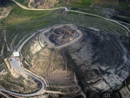
Herodion – King Herod’s Palace from above (credit: Wikipedia)
You can visit Herodion National Park’s official page to learn more. The park displays the ruins of King Herod’s Palace, including tunnels and structures that highlight its historical importance.
History and Description of King Herod’s Palace
Herod the Great constructed his palace at Herodium between 23 and 15 BCE, showcasing his engineering genius. Located twelve kilometers south of Jerusalem, this fortress-palace sits on an artificially raised hill, creating a striking landmark. In fact, Herod designed Herodium as both a lavish palace and a fortified retreat, reflecting his concerns about rebellions.
Additionally, the upper palace features a circular design with four towers, offering breathtaking views of the Judean Desert and Dead Sea.
Visitors explore luxurious living quarters, bathhouses, and a small theater. Furthermore, the lower Herodium includes administrative buildings, gardens, and a large pool.
Secret tunnels, later used by Jewish rebels during the First Jewish-Roman War (66–73 CE), add intrigue. Archaeologists uncovered frescoes, mosaics, and advanced water systems, highlighting Herod’s ingenuity. In 2007, researchers discovered Herod’s tomb, cementing Herodium’s historical significance.
Herodion National Park preserves these ruins, inviting visitors to walk through tunnels, view synagogue remnants, and admire the architecture.
Jerusalem’s Reunification and Strategic Urban Planning
After the Six Day War in 1967, Jerusalem reunited, and city planners developed a strategy to maintain its unity.
For example, they built Jewish neighborhoods around Arab areas to prevent division into Jewish West and Arab East Jerusalem.
In the north, developers constructed Maalot Daphna, Givat HaMivtar, Neve Yaakov, and French Hill. To the east, they established Maalei Adumim. In the south, Gilo and Har Homa emerged, with Har Homa completed last.
As a result, this layout blocked contiguous Arab land connections between Jerusalem and surrounding territories, ensuring the city’s unity. Nearby, Herodion National Park reflects the region’s rich history, from Herod’s era to today.
Experience Herodion National Park
Visiting Herodion National Park lets you explore King Herod’s Palace and its scenic surroundings. In particular, the elevated site offers stunning views of the Judean Desert and Dead Sea, appealing to history buffs and nature lovers. Therefore, wander through ancient tunnels, admire architectural remnants, and dive into Herod the Great’s legacy.


0 Comments